Exciting news! Twenty-five more Trans Canada Trail sections have been accessibility-mapped and added to the AccessNow app, available on the Apple app store and Google Play. The Accessibility Mapping Program, started in 2020 to share information and improve accessibility on the Trail, works with trail users with disabilities to collect and disseminate information through AccessNow technology. Trail users in 54 communities, across every province and territory, can now obtain accessibility information for at least one trail in their area.
“We have adopted a lived-experience approach to assess and communicate the current accessibility of the Trans Canada Trail so people can make informed decisions. Equally important, the program provides essential feedback to local trail groups and municipalities regarding any changes they need to make to improve accessibility on the Trail,” says Eleanor McMahon, President & CEO of Trans Canada Trail. “As a leader in Canada’s trail sector, Trans Canada Trail is committed to creating safe, inclusive access to nature for people of all abilities.”

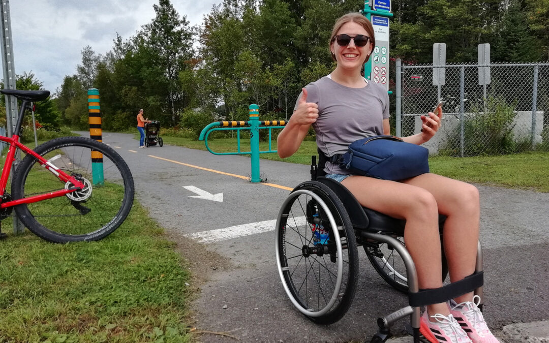
Nineteen accessibility mappers and local trail guides captured their lived experiences
United by their enthusiasm for enjoying the outdoors, 19 mappers brought their diverse backgrounds and lived experiences to the Accessibility Mapping Program this year. Paired with a local trail guide, each mapper navigated a section of the Trans Canada Trail and used data collection, photography and narrative descriptions to capture their lived experience. These observations were uploaded to the AccessNow app and website where trail users can reference this accessibility information so they can make informed decisions about travelling along sections of the Trans Canada Trail.
“At AccessNow we are mapping parks and trails to empower people with disabilities to discover the accessible outdoors. Access to information helps people of all abilities self-assess and reduces the risk of experiencing barriers in order to promote safe and inclusive adventures. On the AccessNow app, users can not only discover exactly what to expect along the mapped trail sections but are also encouraged to share their own perspectives and experiences,” says Maayan Ziv, Founder & CEO of AccessNow.
New in 2023! The following 25 sections of the Trans Canada Trail are the latest to be accessibility-mapped and are now available on the AccessNow app:
Alberta: Strathcona County (mapper: Nicole Palladino); Glenbow Ranch Provincial Park (mapper: Alex Wist)
British Columbia: Kettle Valley Rail Trail in Penticton (mapper: Cameron Lochhead); City of Vancouver (mappers: Kyle Gieni/Richard Peter); City of Nanaimo (mapper: Heather Hutchison)
Manitoba: South Whiteshell Trail (mapper: George Loewen)
New Brunswick: The Marshes in Sackville (mapper: Clary Stubbert)
Newfoundland and Labrador: Newfoundland T’Railway in Gander (mapper: Kim White)
Northwest Territories: Range Lake Trail, Niven Lake Trail, Frame Lake Trail in Yellowknife (mapper: Riley Oldford)
Nova Scotia: Shubie Park Greenway Corridor, Halifax Waterfront Boardwalk and Dartmouth Harbourfront Trail (mapper: Anton Jacobs-Webb)
Nunavut: City of Iqaluit – Frobisher Bay-Sylvia Grinnell Territorial Park (mapper: Noah Papatsie)
Ontario: Pan Am Path-Lower Don Recreational Trail in Toronto, Waterfront Trail in Mississauga (mapper: Tai Young); City of Sault Ste. Marie (mapper: Jake Smellie)
Prince Edward Island: Confederation Trail in Summerside (mapper: Alan Stanley)
Quebec: Lieu historique national du Canada du Canal-de-Lachine in Montreal (mapper: Alicia Pauld); Le Corridor des Cheminots in Quebec City (mapper: Abi Tripp)
Saskatchewan: Pilot Butte Pathway in Pilot Butte, Wascana Valley Trails and Regina West (mapper: Lisa Franks)
Yukon: Village of Haines Junction – Pine Lake Trail (mapper: Pat Moore)

Trans Canada Trail’s Accessibility Mapping Program is generously supported by Manulife in alignment with their Impact Agenda. Through the Impact Agenda, Manulife is committed to making lives better through three interconnected pillars of focus – including accelerating a sustainable future to preserve the planet we all share.
“At Manulife, we recognize the link between our environment, human health and the well-being of our communities, which is why we are excited to partner with Trans Canada Trail,” said Tom Crohan, Global Head of Community Investment, Manulife. “By using technology to document the lived experience of trail users with disabilities and by providing employment to trail mappers, this ambitious project helps connect more people to nature, and increases awareness about the positive impact our natural environment can have on our mental and physical health. We are especially proud to make this strategic investment in an organization that shares our dedication to diversity, equity, inclusion and accessibility, and we look forward to working together in the years ahead.”
As part of Trans Canada Trail’s commitment to making the Trail more inclusive, more than $1.8 million in funding has been provided to local Trail groups to support accessibility improvements since 2020.
Resources:
- Learn more about Trans Canada Trail
- Find the AccessNow app on the Apple app store or Google Play