If you’re looking to get out and explore all that Canada has to offer, look no further than the Trans Canada Trail.
The Trans Canada Trail is the world’s longest recreational trail network, with over 24,000 km of interconnected nature trails, water routes and roadways across Canada. Whether you’re looking for scenic mountain views, a day by the waterfront, or a city expedition, the Trans Canada Trail has something for everyone. It is located in 13 provinces and territories, making it convenient to access no matter where you are in the country.
What’s even more exciting is that the Trans Canada Trail is quite accessible in many areas. That’s right, there’s no need for off-roading on these trails! All of the routes listed here are suitable for all ages and abilities, including many that are fully paved.
So without further ado, here are 14 accessible trails you should explore in Canada:
British Columbia

Photo Credit: Justa Jeskova, Tourism Whistler
Valley Trail – Whistler
Distance: 40-km
The Sites: Whistler’s Valley Trail is a wide, asphalt-paved network connecting Whistler’s neighbourhoods, lakes, viewpoints and picnic spots. The smooth terrain makes it perfect for wheelchairs, tandem bikes, hand bikes as well as gentle walking.
Our recommendation: There is so much to explore, but popular loops include the Whistler Golf Club Loop (4.3 km) with its picturesque scenery and the Creekside to the Lakes Loop (6.4 km) taking you on a tour of three of Whistler’s lakes.

Photo Credit: PlanetWare
Distance: 10-km
The sites: The Stanley Park Seawall is a paved waterfront pathway and is one of the most popular recreational spots in Vancouver. There are different attractions around the path and various areas to enjoy the outdoors including: playgrounds, forests, lagoons and lakes, beaches, and more.
Our recommendations: The Trail is divided into two clearly marked sections, one for pedestrians and one for cyclists. There are many entrance and exit points, and views from every part of the route are amazing. If you have extra time while you’re there, definitely take a stroll into Stanley Park and stop at The Stanley Park Pavilion for a bite to eat.

Photo Credit: 10 Adventures
Distance: 102-km
The sites: The Bow River Pathway is an accessible trail in the middle of Calgary. Following along the Bow River, it offers scenic views of the city centre with mostly a flat, paved trail with several access points, rest stops including benches and washrooms.
Our recommendations: There are steep ramps to traverse the bridge that goes over to Princes Island Park. For optimal accessibility, we suggest exploring anywhere in the East Village.
Saskatchewan

Photo Credit: Trans Canada Trail
Distance: 6-km
The sites: The Wascana Trail is a scenic path that winds through Regina’s historic city centre. This much-loved green space is the geographic and cultural centre of the city. The park provides a green setting for many of the city’s key attractions including the Provincial Legislature building, the University of Regina, Saskatchewan Polytechnic, the Conexus Performing Arts Centre, the Saskatchewan Science Centre and the waterfowl and grassland reserve. These are easily accessible from the trail, which is open year round and is well-used by pedestrians and cyclists.
Our recommendations: Note that there are no railings beside the waterfront area of the trail, however, there is contrast from the paved trail vs. the grass. There is a side path to go to University of Regina where accessible washrooms can be located. Other accessible washrooms can be found along the path, and some have water fountains. The underpass is prone to flooding for a few days in the spring every year.

Photo Credit: Saskatoon Pics
Meewasin Trail – Saskatoon
Distance: 60-km
The sites: “Meewasin” is the Cree word for beautiful, which aptly describes this oasis of exceptional beauty in the midst of the Saskatchewan prairies. From Pike Lake in the southwest to Clarke’s Crossing in the northeast, the Meewasin Valley follows the winding curve of the South Saskatchewan River as it passes through the rural municipality of Corman Park and the city of Saskatoon. The trail runs along both sides of the river, winding under the bridges, and through beautifully landscaped parks and natural areas.
Our recommendations: This trail is mostly accessible and includes different terrain types such as smooth pavement, brick, hard packed gravel, and boardwalk. Be cautious over the railroad crossing with wood pieces, as there is a gap between the wood and the rails which could catch smaller wheels. If you’re looking to spend a nice afternoon along the trail, Gabriel Dumont Park offers a children’s playground, picnic tables and fire pits, benches and lovely river views. The Spadina Avenue portion of the Meewasin Trail, just north of Kinsmen park, is also a stunning spot to see the Fall colours if you’re visiting in autumn.
Manitoba

Photo Credit: The Forks
Distance: 91-km
The sites: This vast section of the Trans Canada Trail network is an ideal way to explore Winnipeg. The trail enters and exits the city on the Red River and follows the Red, Assiniboine and Seine Rivers past many landmarks and historic sites, as it runs through forests, parks, greenway corridors, residential neighbourhoods, and along old rail lines and creeks. Other highlights include University of Manitoba, Assiniboine Park, Fort Whyte, Riverwalk, Museum of Human Rights, Esplanade Riel and Fort Gibraltar.
Our recommendations: There is a mix of different ground types; pavement, hard packed gravel, loose gravel and dirt trails. However, there are plenty of well paved areas that are very accessible. You should visit The Forks, where the Assiniboine flows into the Red River. It has long been a meeting place for Aboriginals, fur traders, and immigrants and now is a National Historic Site and popular cultural hub. With that being said, we recommend taking caution on this part of the trail, as well as the part of the trail that runs from Whittier Park to Park Joseph Royal, as the terrain may be uneven in some areas.
Ontario

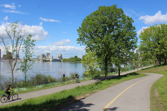
Photo Credit: Ottawa Tourism
Distance: 25-km
The sites: This section of the Trans Canada Trail links to superb natural areas, parks, gardens, museums and attractions. Enjoy fresh air, exercise, beautiful look-outs and rest areas with benches, and scenic landscapes on paved paths that follow along the Ottawa River, and extend from Gatineau Park, through Ottawa and into the Greenbelt. There are also many routes that lead to downtown Ottawa and Gatineau.
Our recommendations: For the most part, the Capital Pathway is fully paved asphalt, but some segments of the trail have steep inclines and will require multiple ups and downs. Furthermore, the only way to get across the canal is over the locks, which unfortunately are not accessible at all. If you choose to explore this section of the trail, you may have to detour around the locks.

Photo Credit: TVO
Great Lakes Waterfront Trail – Toronto
Distance: 40-km
The sites: The Great Lakes Waterfront Trail is a shared-use trail that connects Toronto neighbourhoods throughout the Greater Toronto Area. The trail passes by several points of natural, cultural and industrial heritage, including several historical bridges and other examples of Toronto’s railway history. It is habitat for some regionally rare plant species and home to a wide range of wildlife including deer, fox, coyote, and various species of bird.
Our recommendations: You will have the opportunity to see plenty of picturesque scenery along this Trail, but definitely make an effort to stop by Rouge Beach Park, which offers stunning views of Lake Ontario and Toronto’s largest wetland / marsh area. The downtown section of Waterfront Trail along Queen’s Quay is also beautiful, as is the iconic Humber Bay Arch Bridge south of Lake Shore Boulevard West.
Québec

Photo Credit: Eastern Townships
Les Grandes-Fourches – Sherbrooke
Distance: 87-km
The sites: This is a multipurpose paved path, with two access points and scenic resting areas, located in the heart of downtown Sherbrooke. It also includes the Lac de Nations pathway, which is a 3.5km loop around the lake. The trail passes by an information center and a farmer’s market.
Our recommendations: There are plenty of benches to rest at and enjoy the scenery. The path is maintained and accessible year round.
New Brunswick

Photo Credit: Eh Canada Travel
Distance: 20-km
The sites: This section of the Trans Canada Trail consists of paved and gravel trails that follow along the Petitcodiac River. The trail is open all year round, and connects downtown Moncton to Dieppe and Riverview. The trail features skateparks, sports fields, historical monuments, a lighthouse, sheltered rest areas, picnic tables and benches, and a Visitor Information Center located in the Treitz Haus (the oldest building in Moncton). It passes through Bore Park, one of Moncton’s oldest public parks.
Our recommendations: There is a section of the trail that goes across Findlay Boulevard, which is a fairly busy highway. We highly recommend avoiding this section due to safety. With that being said, don’t miss out on seeing the most impressive Tidal Bores in the world, which happens along the shore of the Petitcodiac River. These bores typically happen twice a day, when the tides from the Bay of Fundy push up the river towards Moncton. The size of the waves can be up to 1m tall and can move as fast as 13 kilometres per hour. You can get a good view of this phenomenon at Bore Park.
Prince Edward Island

Photo Credit: Tourism PEI
Distance: 461-km
The sites: The trail offers beautiful rolling scenery, quaint villages, hardwood groves and stunning seascapes. The main trail starts in Tignish and ends in Elmira, but branch trails run into the heart of Charlottetown and to the waterside communities of Souris, Georgetown, Montague, Wood Islands, Murray River and Murray Harbour, plus link to the Confederation Bridge in Borden-Carleton.
Our recommendations: PEI’s tip to tip Section of the Trans Canada Trail — the Confederation Trail — never exceeds a 2 percent gradient (up or down) the entire time, making it a very wheelchair friendly trail. Check out Destination Canada’s article for tips on planning a trip on this trail, including must-visit sections to explore.
Nova Scotia

Photo Credit: Tripadvisor
Distance: 110-km
The sites: Part of Trans Canada Trail’s Celtic Shores Coastal Trail, The Harvest Moon Trailway is a multipurpose and shared use trail that offers picturesque scenery travelling through orchards, fields, and forests. It is a quaint spot isolated from the main road. Some sections are paved, but the majority of the trail is hard packed gravel or earth.
Our recommendations: There are many benches along the trail for rest, or to stop and enjoy the scenery. Be sure to check out some of the trail’s main highlights like the Annapolis Royal Historic Gardens, the Fort Anne National Historic site, and the Landscape of Grand Pré World Heritage Site. Please note, however, that there are several gates on the path that are a bit narrow and might be challenging to pass through using a power chair.
Newfoundland

Photo Credit: Tripadvisor
Distance: 3.9km
The sites: The Quidi Vidi Lake trail is a trail that loops around the lake. It has many benches along the path, for resting and enjoyment of the scenic views, as well as bird watching. This mostly flat trail is a well-loved community hub. It has some areas of hard packed gravel, some paved areas, and also features a boardwalk with accessible lookout points.
Our recommendations: You can start anywhere on the loop, but Quidi Vidi Park, off The Boulevard, is one of the most popular parking areas. Stop by the dog park for a visit with some furry friends, or spend an afternoon by the beach (during the summer, you might even see rowers prepare for the Royal St. John’s Regatta!)
Yukon

Photo Credit: Yukon News
Distance: 23-km
The sites: This section of the Trans Canada Trail runs through the town centre and along the majestic Yukon River, providing access to many of the city’s main sites, including the Rotary Centennial Bridge. It is mostly flat and paved, and features scenic viewpoints with some resting areas and benches.
Our recommendations: Don’t miss the SS Klondike nearby, one of the largest 1930s sternwheelers to travel the Yukon River and now a National Historic Site of Canada; the Kwanlin Dϋn Cultural Centre, celebrating the heritage of the First Nations people; and the Whitehorse Fishway, the largest wooden fish ladder in the world.

About the Author
Tori Hunter is a writer and travel enthusiast, passionate about redefining the way we view accessibility and the disabled experience. She has worked alongside numerous organizations to help dismantle access barriers, and in her free time, she likes to share her adventures as a wheelchair user on her Instagram @torihunter.blog
Latest on the blog

The World Works Better With Us – Disability Pride 2026
July is Disability Pride Month, and this year's theme is: "The World Works Better With Us." There's a real idea behind that theme, and it has a name: the curb-cut effect. It's named after those sloped ramps cut into sidewalk corners. They were built in the 1970s so...
Accessible Trails to Discover in the GTA and Beyond This Summer
Summer in Ontario means longer days, warmer air, and a whole province of trails waiting to be explored. Whether you're looking for a quiet, paved walk or a trail that keeps you busy and runs for kilometers, there's a route out there for you. We've pulled together nine...

& Juliet’s First Chilled Performance Comes to Toronto!
This summer, & Juliet is doing something special. On Thursday, July 2, the Royal Alexandra Theatre will host the show's first-ever Chilled Performance - a more welcoming, lower-pressure way to experience one of the most joyful musicals on stage right now. If...